
We took advantage of the long weekend to go to the United States to hike Gothics Mountain in the Adirondacks.
A fine 21.8-kilometre challenge on paper (because in practice it was a little longer for us).
Presentation
Gothics Mountain is quite an imposing mountain, especially with its beautiful rocky headlands. At 1442 m, it is the 10th highest peak in New York State. It's part of the Adirondacks and one of the famous "46 summits" (you can also do Mount Saddleback, which is also one of the 46 summits, but that's an extra 2 km or so).
This hike is classified as difficult. You'll find a popular staircase to get you over the first rock face. Then there are ropes to make life easier on other rock faces. Despite this, some passages are still a little tricky, so take care.

In my opinion, if you're new to hiking, this is not the first one I'd recommend. It's quite long and some parts can be a bit tricky, especially if the weather isn't on your side.
Apart from that, it's a fine hike, although it doesn't offer much in the way of views until you get close to the summit.
Practical information for making Mont Gothics :
Before To begin with, I'd like to remind you that I try to update this information as often as possible, but things can change from one year to the next. So remember to check things out before you go. (Last updated June 2022)
The numbers (according to my Garmin):
It should be noted that these figures have been done in summer and starting from the second parking lot, at the Valley Grocery Store, see the Garmin route below.
- Duration: Approx. 11 h 30 min
- Ascent: 1247 m
- Length: 26.8 km
- Maximum altitude: 1442 m
Starting point: The starting point is The Garden Trailhead. There are other starting points, with longer loops, but this is where you'll find the fastest round trip.

Parking : The main car park is at the same location, The Garden Trailhead. This is a small lot, however, and parking is not permitted on the road leading to the parking lot. There is a second car park next to Valley Grocery Store. The latter is not very big either, and will add 2.5 km to the outward and return trips (making the hike 5 km longer). Think about leaving early or consider doing the mountain in two days, sleeping on the mountain.
Recommended equipment: This is a long and relatively difficult hike. Remember to have enough food and water. I recommend good shoes, as the trail can easily get muddy in the forest and the rocky headlands can be sheer and slippery. Walking sticks are also useful. The summit can be very windy, so remember to take a windbreaker with you. Finally, a GPS (or GPS watch) can be useful. There are several forks in the trail that can sometimes be confusing, but my GPS watch helped us confirm which path to take.
Remember to check the weather forecast and register at the start of the hike.
Our hiking experience at Gothics Mountain:
We thought we'd be up early, aiming for a 7:00am start. In the end, we were already "late". Because when we arrived, the parking lot was full. According to the parking lot attendant, it had been full since 5:30 a.m... We were a little too optimistic.
However, I don't think it's necessary to arrive at the parking lot before 5:30 a.m. all the time. We were there over the weekend, a three-day weekend for Quebecers, and the weather was very nice. Part of the parking lot was also occupied by people sleeping on the mountain and we wouldn't have been able to get there before them anyway.

Never mind, we'll take the car and park in the "emergency" lot near the Valley Grocery Store. We recover one of the last parking spaces. But there's no joy in it, as this change of plan adds 5 kilometers to our already long planned walk.

We begin our long journey without delay. We follow the road we've just taken by car, but this time on foot. And this road isn't flat, it's uphill. We arrive at the first parking lot after a good half-hour's walk. We sign in, check the map and continue (start?) the walk.

A large part of the hike takes place in a fairly dense forest that climbs very gently. It's a far cry from the steep climbs of Charlevoix. We gain altitude without really realizing it. Nothing really difficult on the whole forest section.

We come across a number of refuges and camping sites for people doing the hike over several days. There are a few small rivers to cross. The largest has a beautiful wooden bridge.

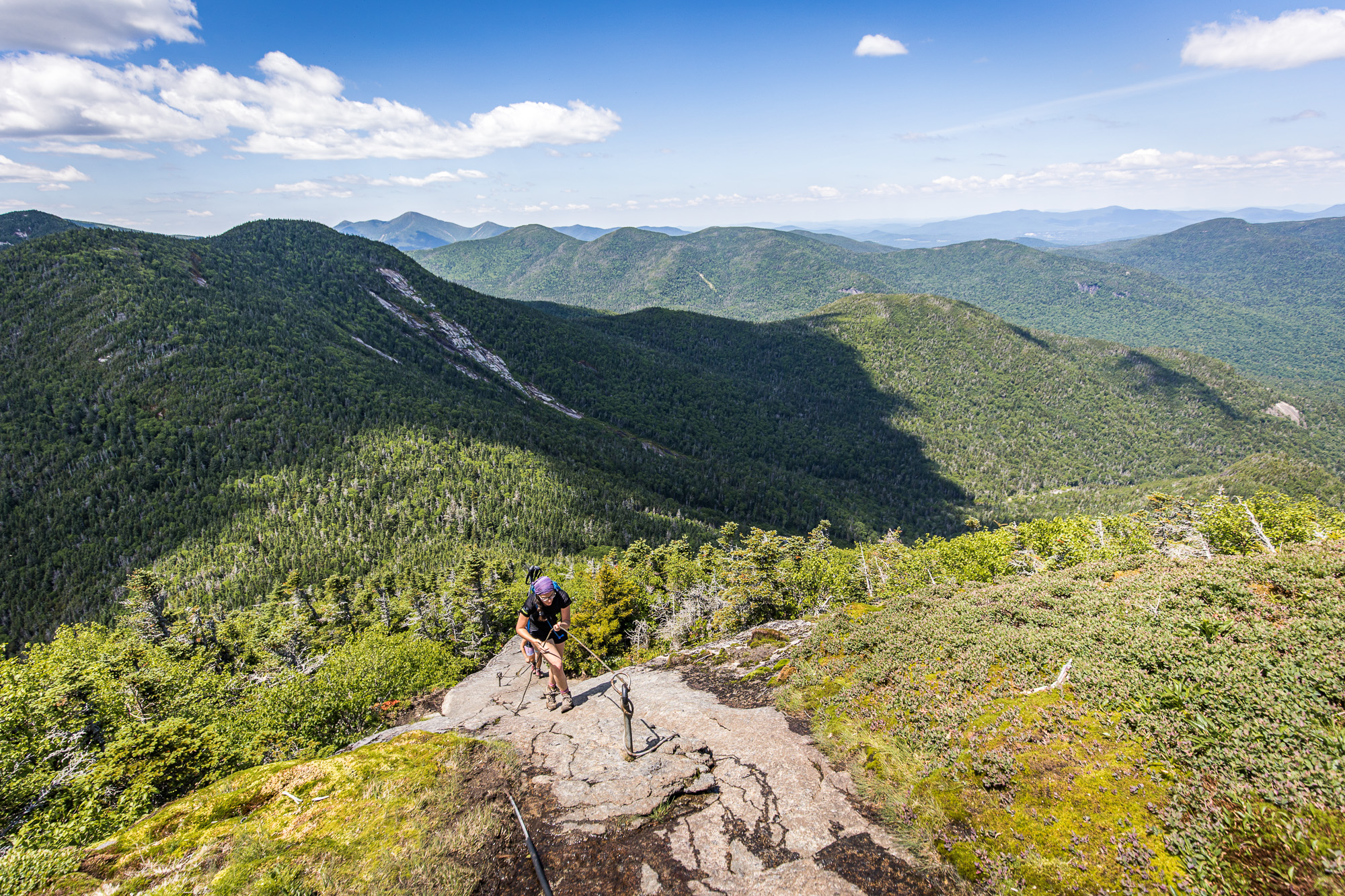
As we leave the forest, we come across our first big rock face and our first difficulties. The wall is a little slippery, but we start climbing it with some difficulty. Fortunately, we soon realize that we've missed a staircase on the left that will make life a lot easier.

We set off again for a short stretch in the forest before coming across new rock faces. This time, part of it is protected by ropes (or steel wire to be precise). They're a real help, and we're sorry there aren't more of them along the way. Some rocky slopes are devoid of them, and this has an impact on our progress, as these passages are not much easier than those where the ropes have been installed.

We reach the first summit. For a few moments we thought we were at the real summit, but my watch was clear: there was still a little way to go. It was astonishing to find a summit with hardly anyone and no sign.

Finally, it's back down through a small forest and then up again to find the true summit of Gothics Mountain and its plaque (there are also many more people taking a break here).

At last, it's time for our meal and a well-deserved break. The break doesn't last long, though, as we have to think about heading back down the mountain, which means another good 5h30 of walking.

Time for a selfie and a few "summit cookies", and we're off the way we came. It's possible to do Gothics Mountain with different loops, but the route is quite long (30km minimum), so we'd opted for the "21 kilometers only" round trip (before it turned into 26 kilometers because of the parking lot).

The return journey seemed a little interminable, the forest section being relatively uninteresting and the descent of the rocky slopes rather... rock'n'roll. But all goes well, and we're back in our cars after an 11:27 hike.
For the curious, here's our route recorded with my Garmin:


